Stevenston Point and Ponds

Location and Access

Stevenston is one the Three Towns on the Ayrshire coast and has several good birdwatching locations. The main one is Stevenston Point at NS 270 402. To get there follow the signs for the West Car Park. This is a beach park built on an old industrial area. The Point sticks out slightly into the Firth of Clyde and gives good views of Irvine Bay.

By following Moorpark Road West you get to Auchenharvie Golf Course (NS 264 414) with its two ponds. You can park near the clubhouse. A track skirts the south side of the golf course towards the westerly pond and gives good views. Due care and consideration should be given to the golfers.

Auchenharvie: Park in lay-by, easy viewing from car, large unsurfaced car park at golf course, path across golf course to west pond unsurfaced with potholes.

Easily accessed from nearby National Route 73, Ardrossan to Kilwinning.

Birds

Stevenston Point’s location makes it good for watching birds pass up and down the Firth of Clyde, such as Fulmar, Gannet, Manx Shearwater and occasional Skuas, Little Gulls, Storm Petrel, Sandwich Tern. This is also a good spot for checking out ducks with flocks of Eider, Tufted Duck, Common Scoter (and a superb male King Eider in 2003). One or two Long-tailed Duck also spend part of the winter here. In recent years a Whimbrel has over-wintered. It is best looked for in the rocks at the Point (although it can be elusive). The burn mouth is a good gull and wader (Dunlin, Redshank, Turnstone, Curlew, Oystercatcher, Ringed Plover, occasional Golden Plover, Knot, Sanderling, Purple Sandpiper) roost. A pair of approachable Snow Bunting were on the beach here in early Spring 2001. The rough ground near the beach often have flocks of finches. The grass around the Point is good for Wheatear on passage, and for gulls and Oystercatcher feeding.

The ponds on the golf course have different characters. The one nearest the clubhouse is smaller and edged with reeds. It has breeding Dabchick, Mute Swan, Tufted Duck, Coot. The larger pond, nearer Saltcoats, is better in winter and is a great place to get close views of Scaup with up to 150 individuals. There are also various hybrids with Tufted Duck to test your ID skills. Mute and occasional Whooper Swans also hang around this pond. Nearby is the meat factory: check out the roof for the recurring Glaucous Gull.

Brisbane Glen, Largs

Location and Access

Noddsdale (or Brisbane Glen, as it is marked on the OS Explorer series map) runs from Largs on the Clyde Coast (on the A78 26km north from Irvine and 22.5km south from Greenock), north-north east into Clyde Muirshiel Regional Park. Starting at the mouth of the Noddsdale Water (NS 198 605) the head of the glen is reached some 11km inland (NS 251 678) having risen to about 270m. Access to the glen is via the minor road, on the right as you travel north, which is clearly signposted – Brisbane Glen Road – towards the north end of Largs from the A78. Private transport is essential unless you are prepared to walk or cycle.

Once out of town there are no marked paths until Outerwards Reservoir is reached. Next to the reservoir is a car park, picnic area and woodland and moorland trails associated with Outerwards Community Woodland. Otherwise, the glen is enclosed and the normal countryside code and access conditions must be observed. Just over the watershed north into Inverclyde lies the Cornalees Centre of Clyde Muirshiel Regional Park, a ranger base with woodland and moorland walks, toilets, shop and refreshments.

Brisbane Glen is named after Thomas Brisbane who also gave his name to the city and river of Brisbane, Australia. Thomas was a keen astronomer building his own observatory near Largs and establishing another near Sydney while he was Governor General of New South Wales. Also named after him are a planetarium in Brisbane and a crater on the moon.

Byway suitable for bikes with access from either Largs or Greenock.

Habitat

Noddsdale Water (Brisbane Glen) is listed in the Ayrshire Local Biodiversity Action Plan as a Provisional Wildlife Site.

The first kilometres of the road pass through the outskirts of Largs. Beyond the boundary of Largs great care should be exercised if parking a car as the road is narrow and twisty. On leaving the built-up area the countryside at these lower reaches of the glen consists of improved grasssland to enable usage as pasture and the road passes along past hedgerows with mature deciduous trees frequent. At this stage there is no sign of the Noddsdale Water as it is between 100m and 200m to the left of the road, hidden by the trees which line its banks. The trees along this stretch comprise mature native deciduous species and conifers. Half a kilometre further on the wood widens out to stretch up the north slope of the glen and about 1km towards the head of the glen. By this time the glen has narrowed and the road passes out on to a more open aspect and the surrounding moorland opens up to reveal a new habitat. A short distance further on the Outerwards Reservoir appears with a good stand of mixed, mature woodland surrounding the north-east corner. Once beyond the reservoir Noddsdale Water becomes a relative trickle and the outlook is purely moorland with the exception of a stand of mature conifers adjoined by a plantation of conifers up to about 4 metres in height. The south-eastern slopes of the glen are split by several small, rocky burns which provide the opportunities for species such as Rowan (Sorbus) to establish a foothold and break up the predominantly brown shades with streaks of green.

Birds

Given the variety of habitat throughout the length of the glen it should be possible to find many common species such as various finches, and tits along with Grey Wagtail, Robin, Wren, Blackbird and Dunnock. In summer these will be complemented by warblers in the lower and middle reaches and Whinchat – joining the resident Stonechat – and Wheatears higher up. Of course, some species fewer in number can also be much more obvious and sight of Buzzards wheeling over the glen or rushing through the woodland should be no surprise. Out on the moor Meadow Pipit and Skylark may be numerous in summer and their numbers may swell in autumn when northern migrants pass through. Also out on the moor Curlew and Short-eared Owl may be present and there is the possibility of seeing Raven, Red Grouse,Cuckoo – most likely heard calling from a hidden perch – or, if you are lucky, a Peregrine or Hen Harrier.

In the lower and middle reaches more elusive species such as Treecreeper, Goldcrest and Great Spotted Woodpecker might be found in the woodland and Noddsdale Water itself may produce Grey Wagtail or Dipper.

During the winter months the moorland will be largely empty of birds although the middle and lower reaches may be productive of flocks of finches and tits and there is habitat also for winter visitors such as Fieldfare and Redwing.

Surrounded by gardens, waterfalls and mixed woodland, below the castle is a walled garden which, like the New Zealand Garden and other parts of the park, grows exotic flowers and shrubs that thrive in the mild West Coast climate. The Country Centre is open to the public for most of the year and offers a wide range of recreational activities including horse riding, children’s play areas, and adventure wood, exhibitions, a tea room, a cafe and a gift shop.

Noddsdale Water, Largs

Location and Access

Largs is situated by the Clyde estuary on the A78, some 26km north of Irvine and 22km south of Greenock. The town itself provides an opportunity for family birding, having a range of facilities and attractions to cater for non-birders. For those not wishing to use a car there is an hourly train service from Glasgow Central station and those travelling from southern and eastern Ayrshire can join the Largs train at Kilwinning. Regular bus services operate in both directions along the A78. There are 2 options for car-parking: payparking on the waterfront or parking for free on the streets off the waterfront. Both options can be difficult during the summer and the latter is not likely to endear visitors to the residents.

The mouth of Noddsdale Water (NS 198 604) is reached at the northern end of Largs. From the centre of Largs it is a 1km walk north along the sea-front, or if driving, continue north along the A78 tojust beyond the Queens’ Hotel and turn left into Aubrey Crescent. At the end of the crescent, with luck, you should be able to find a parking space and can proceed on foot. There is a paved footpath leading into a small public park which has a sandpit and climbing frame for children and pond which is used by model boat enthusiasts. Conveniently,there are also toilets and a gazebo to provide shelter.

Easily accessed from Ardrossan to Largs coastal cycle path.

Habitat

The beach is comprisedof shingle whichis steeply banked due to the action of the tides. The burn enters the sea over this area of raised shingle, which around the mouth of the burn, forms a broad, level area where seaweed can find a foothold. Across on the north side of the burn the shingle beach continues but above the shingle the habitat is very different from the managed south side. Naturally growing flowering plants and grasses provide cover and food which could make that area worth a good look, especially outwith the summer season. Manicured lawns in the park, which also has mature deciduous trees, provides a contrast and another set of habitats. The short grass could prove attractive to a number of ground-feeding passerines, while the mature trees give opportunities for leaf feeders. Noddsdale Water forms the northern edge to the park and the well-grown gardens on the other side over-hang the burn with well established native deciduous trees and a variety of shrubs. Where the burn crosses the shingle it provides a good bathing area for preening birds.

Birds

Offshore all species of diver are possible during spring and autumn, Gannet in the summer and Cormorant and Shag at any time of the year. Winter is the best time for the variety of wildfowl that it is possible to encounter in the Clyde estuary. Although geese are unusual here ducks such as Eider, Goldeneye, Red-breasted Merganser can be found offshore with Wigeon, Teal and Mallard all likely.

The areas of seaweed provide feeding for Curlew and Oystercatcher throughout the year while the Redshank is common along this coast and Turnstone orPurple Sandpiper might turn up. Starling and crows are always avid searchers of seaweed. All of the commoner gulls can be viewed here, bathing in the fresh water provided by the burn and making the most of the food provided by visitors. Within the park you might expect to see commoner passerines such as Pied Wagtail, Blackbird, Song Thrush, Robin, Dunnock with Great and Blue Tit in the trees while the burn itself and the vegetation on the other side could give Grey Wagtail and warblers. The vegetation on the wilder north shore could be worth a look for seed-eaters during the autumn and winter months with species such as Goldfinch, Greenfinch and Linnet being likely.

Great Cumbrae

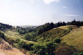
An easily accessible small island off the Ayrshire coast, approx. 6km long and km across at its widest point. The west side of the island has an especially remote feeling. The walking is easy, mainly on surfaced but sparsely used roads, save for cycles in summer. Bird life is particularly abundant in springtime.

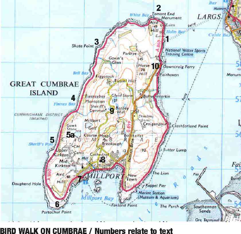
This article is accompanied by an annotated map and photos to show various parts of the island.

Distance

From the ferry pier known as Cumbrae Slip at Holm Bay to Millport via Tomont End, Fintray Bay and Portachur Point – the walk is around 12 km. To walk the full circle – an easy 20 km. However, the stretch of road between Millport and the Cumbrae Slip tends to be busier – so the frequent bus service is another option here.

Access Details

Park your car at Largs seafront car park (charge) and travel as a foot passenger on the CalMac ferry from the nearby harbour. The ferry operates a 0 minute headway in summer – and hourly in winter. (Telephone CalMac at Largs: 01475 – 674134 for details). If you wish to do it the lazy way – you can get a day return for your car and all your passengers. Largs is also well served by public transport with an hourly train service provided by ScotRail (tel: 01294 – 272111) and a half-hourly bus service along the coast from Ayr to Greenock provided by Stagecoach Western Buses(Tel: 01292 – 613500) and Arriva.

Buses fitted with wheelchair lifts.

Road mostly follows the coast making for an easy 20km ride. Bikes may be hired in Millport.

Facilities

All facilities in Largs. Portaloos at Cumbrae Slip. Toilets and drinks / light meals at the seasonal Fintray Bay Cafe on Great Cumbrae. All facilities at Millport.

Best Times to Visit

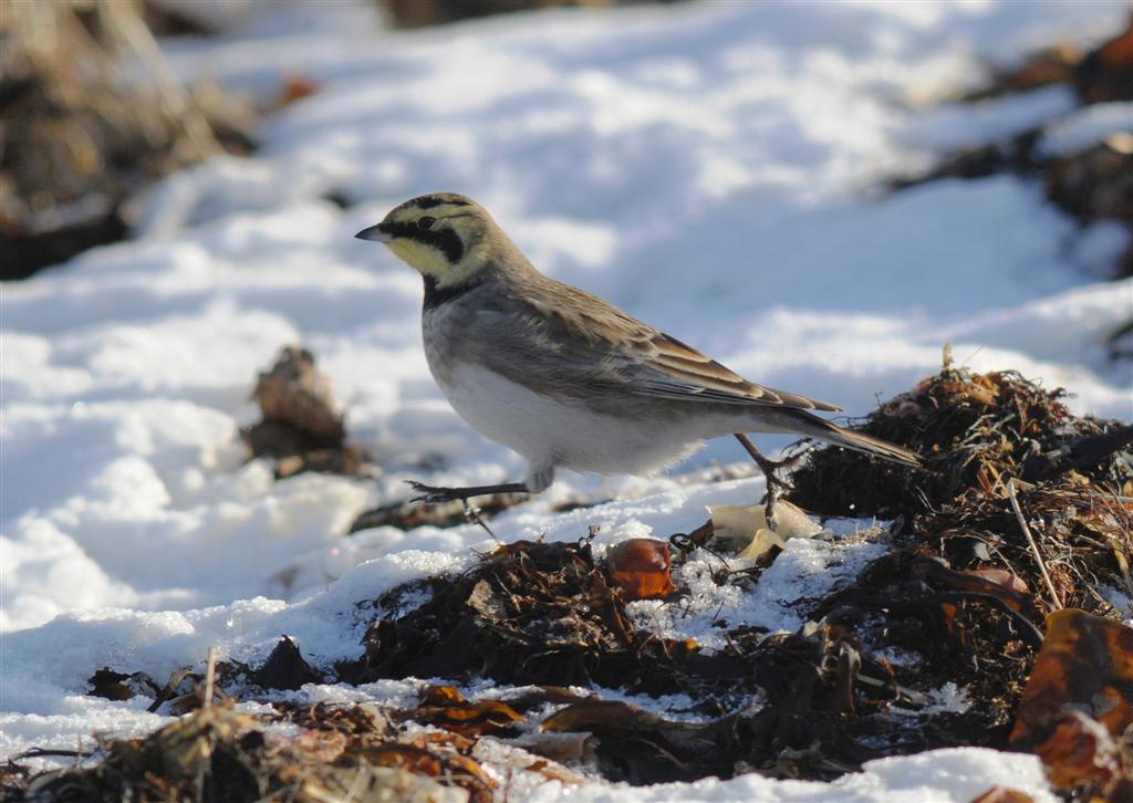
Always something to see, but end of April through to May and early June by far the best. Eiderare spectacular in May, with the mating calls echoing around the shoreline. Lapwing nest close to the road at the north end – this area being particularly good for all seabirds and waders.

The Walk Itself

(Numbers refer to map reference points).

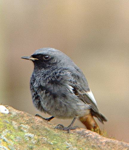
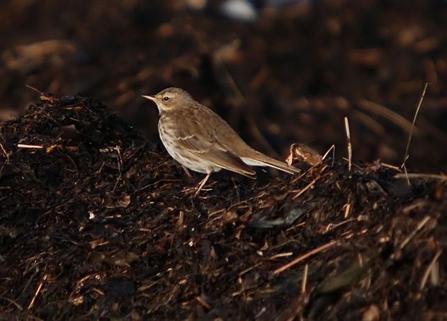
After alighting from the ferry (10 minutes on passage) at Cumbrae Slip (1) – turn right and head off along the surfaced road past Holm Bay towards the north end of the island and Tomont Point and Monument (2). Assuming a springtime visit you should see Whitethroat, Sedge Warbler, Willow Warbler, and both Meadow andRock Pipit. Plenty of Pied Wagtail flitting about as well as Grey Wagtail. All the usual finches, Blackbirds, Dunnock and other common species.

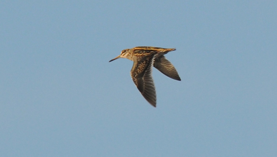
At Tomont End – move out across the rocks to the shore to find Red-breasted Merganser, Shelduck, Oystercatcher as well as all the gulls you may expect to see and possibly more. Move back to the road and carefully peep over the stone wall to see if you can catch sight of Lapwing – which nest around here. From here to Skate Point (3) in particular, there is usually much to see. Gannet may well be plunging into the water, terns are possible and Eider are extremely vocal. Look for Turnstone and Ringed Plover on the rocks and shore and Common Sandpiper, Redshank, Mallard, Cormorant and Shag. Grey Heron may well be gracing the rocky coastline, too. Overhead – Kestrel are to be seen, but so are Buzzard in ever increasing numbers. Sparrowhawk are not uncommon. Along the roadside scrub, Stonechat are around in good numbers and to landward (especially if you return via the inland hill route) you can also expect Whinchat. Curlew are often seen in good numbers to landward and also along the shoreline where Dunlin are sometimes seen. Swallow and Sand Martin may accompany you as you move on towards Fintray Bay (4). In season, you can take advantage of a coffee, tea or soft drink, along with snacks and light meals at the Fintray Bay Cafe. Toilets are to be found here, too. If you bring your own food – there are picnic tables dotted around the island.

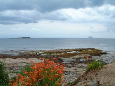
After leaving Fintray Bay, a path strikes off to the left uphill. This lead to the Gowk Stone (5a) and on through the fields, passing the golf club and down in to Millport itself. This is a shorter route if you are running out of time – cutting about 4 km off the main route to Millport via Portachur Point. If you stay with the coast road, it will shortly bring you to Sheriff’s Port (5). The nearby cliffs have breeding Fulmar and Kittiwake are also normally around. Look out for Raven at this point. From here, the road swings around towards Millport – but a pathway leads off towards the shore and eventually comes back to the main road. This will lead you through yellow flag iris to Portachur Point (6) where you can look for Common Seal – Grey Seal may also be visible. Back on the surfaced road, you will soon be in the town of Millport (7), where you will find many watering holes for that stronger drink – or try the Ritz cafe for a bit of thirties nostalgia. The Cathedral of the Isles (8) is also worth a visit – especially if you have decided to return via the hill route. This lies on your way up to Barbay Hill (9) and at 127 metres, provides superb views of the Isle of Arran, Bute and the Cowal Peninsula – as well as the Ayrshire Coast (on a clear day). This unclassified road will eventually bring you to the B899 where you should turn sharply left. A short stretch leads on to Downcraig Ferry (10) back on the coast road (A860). From here, you can see the Cumbrae Slip (1) once again where you will board the ferry back to Largs.

Boat Trips

Boat trips around the Cumbraes are now available. For details see:

Seamill

Location and Access

This is a stretch of the Firth of Clyde from the Waterside Inn (NS 207 460) to the Seamill Hydro (NS 202 471). Access is possible from the car parks on the A78. The nearest train station is at West Kilbride (2km). There is a path along the beach. There is also a good cycle path all along this part of the coast with good views of the Isle of Arran. The best time of year for birding is over the winter (and you avoid the crowds in the summer). This part of the coast is mostly rocky.

No access for wheelchairs – locked gate/wicket gate for pedestrians.

The coastal cycle route from Ardrossan to Largs follows the shore.

Birds

The rocks near the Waterside Inn give good views out to sea and are good for divers (the three commoner species) in winter, Manx Shearwater passing through, Black Guillemot, Gannet, Red-breasted Merganser, and a Little Auk was rescued here. The off-shore islets (Limpet Craig) are roosting sites for Shag, Cormorant, Eider.  The rocks are good for waders including Purple Sandpiper, Redshank, Turnstone, Oystercatcher, and Greenshank (one is resident most winters). Sedge Warbler and Stonechat can be seen in the gorse. The burn coming down the side of the Seamill Hydro is good for bathing gulls and ducks (Wigeon, Teal, Mallard, Eider) while looking up the burn gives a chance of Grey Wagtail and Dipper. A Black Redstart has wintered here several times. Look at the rocks offshore (Brither Rocks) for sunbathing seals.

The tide-line is good for Rock Pipit (but check for Water Pipit too!) and passage White Wagtail. In late 2010 a lovely Shore Lark was in with the various pipits and wagtails feeding on the tide-line.  It is worth going through the duck flocks: Long-tailed Ducks crop up now and again in the winter, and a Green-winged Teal was here in December 2000.

Behind the pumping station is a rough field with a peaty pool. This is very good for Snipe and Jack Snipe (up to 6 at once) and it pays to stomp around the edge (in wellies!). The adjacent field often has large flocks of Curlew (over 200) and Lapwing.

Keep an eye on the fields and woods on the other side of the A78 for Buzzard, Kestrel and lots more Curlew. Also check out the flocks of crows for an occasional Hooded Crow (and hybrids).

Black Redstart at Seamill, ©Jim Duncan, 2002

Dalry River Walks

Location and Access

These are a series of fishermen’s paths along the banks of the River Garnock and its Rye Water tributary, accessed from the town of Dalry in the Garnock Valley. Good footwear essential.

  • The first walk follows the west bank of the River Garnock for 1km south to the car park at car auction house/ former brickworks (NS 295 480).
  • The second is a circuit of 4km from the north-east edge of Dalry (NS 298 498) by footbridge over Rye, then north along the bank path to the River Garnock, and then upstream to Pitcon estate, and then west along the boundary of chemical factoryand return by B780.

There is a regular bus service along the A737, and Dalry has a mail-line rail station.

The area is accessible by bike from Dalry.

Birds

Grey Heron, Dipper, Kingfisher, Grey and Pied Wagtail, Common Sandpiper, Swift, Swallow, House and Sand Martin, and summer migrants such as warblers.

Dalry Community Woodland

Location and Access

This is an area of mixed woodland planted in the 1990s, with a criss-cross of grassed paths. The woodland lies 4km east of Dalry along B707 and encompasses Bowertropping Wood and vicinity of Pencot Farm (NS 2 49). It extends from Blair Mine (NS 25 495) to the OS triangulation point near the farm (NS 28 488). Ideas for further development of the area include a pond or wetland. Cars can be parked at the old mine – but be security conscious. (Note: in June 2003 the entrance to the mine was blocked.)

There is a regular bus service along the A737, and Dalry has a mail-line rail station.

The area is 1.5km off National Route 7.

Birds

A changing scene worth ongoing observation as the habitat diversifies with growth. Expect woodland, scrub and farmland species including breeding Buzzard, Sparrowhawk, Kestrel, Whitethroat, Garden Warbler, Skylark, Magpie, Willow and Sedge Warbler, Mallard, Dunnock, Song Thrush, Swallow, Chiffchaff, Lapwing.

Blair Estate, Dalry

Location and Access

A fine wood and parkland laid out in the 1850’s surrounding Blair House (earliest part 12th century). Bombo Burn flows through the grounds before joining the River Garnock. The estate lies 2km south-east of Dalry along unclassified road past Dalry Station. There are metalled and unmetalled paths which are occasionally boggy. The grounds are private but access is permitted for walkers but no dogs or bikes, and the grounds are occasionally closed – please respect the owner’s wishes.

Cars can be left at either the north or south lodges (NS 06 472), taking care not to obstruct access. Buses and trains go through Dalry, about 2km away.

National Cycle Route 7 passes along the eastern boundary of the estate.

Birds

Woodland species abound in Spring including tits, finches, Chiffchaff, Willow and Garden Warbler, Blackcap, Treecreeper, Great Spotted Woodpecker. Dipper and Wagtails by the Burn. Sparrowhawk, Kestrel, Buzzard, Raven and Jay are present. Good for winter thrushes, Brambling and occasional Waxwing.

Auldmuir Reservoir, Dalry

Location and Access

This is a small hill reservoir at 170 metres on the boundary of farm land with hedgerows and moor with young plantation. It is situated km west of Dalry off the minor road to Fairlie, signposted The Moor Road. It is owned by Dalry Garnock Angling Club and visitors should be considerate to the anglers and the adjacent farm. There is a picnic site with panoramic vistas of the Garnock valley. There is limited parking at the end of the farm track through the gate (please be aware of any livestock and don’t block farm access).

There is a regular bus service along the A737, and Dalry has a main-line rail station.

The area is accessible by bike from Dalry.

Birds

Loch and lochside:
Teal, Tufted Duck, Pochard, Mallard, Dabchick, Grey Wagtail. Breeding Common Sandpiper and Snipe.
Surrounds:
Reed Bunting, Chaffinch, Greenfinch, Linnet, Meadow Pipit, Skylark, Sparrowhawk andHen Harrier.
Others:
Dotterel and White Wagtail have been seen on passage. Continue over The Moor Road for Red and Black Grouse, Short-eared Owl, other moorland species.

Kildonan, Arran

Location and Access

Situated at the south end of the island, Kildonan is signposted off the A841, km south of Whiting Bay. This road circumnavigates the island, following the shoreline closely along the east and west coasts but taking an inshore line along the south, including by Kildonan. The area in front of the Kildonan Hotel and opposite to Pladda Island is a good starting point for a peaceful birding walk.

Parking is available in the marked area (NS 034 207) to the right of the old coastguard tower. Access to the beach is by the steps going past the children’s play area then down along the beach towards the Kildonan hotel. A second marked parking area can be found if you carry on down the road to the old school house (now letting apartments), go on to the sea front, and walk to the right along the beach.

Another good area is along Auchenhew Bay (NS 017 207) nearby to the west. Leaving the last location, follow the road into Kildonan and use the car park opposite the village hall. Turning left, follow the road past the village store and post office, then the footpath onto the raised beach stretching west towards Bennan Head.

Birds

The Kildonan Hotel area is good for Turnstone and Purple Sandpiper foraging on the stone dykes. Dunlin, Ringed Plover, Curlew and Whimbrel also favour this area. Little Stint have been found on the pools above the strand line along with Knot and Black-tailed Godwit. Red-breasted Merganser and Eider are common on the sea. A good number of Manx Shearwater may be viewed offshore in the right season. Iceland Gull has been seen loafing with the resident gulls at low tide.

Passerines including Willow Warbler, Sedge Warbler and Common Whitethroat breed in the scrub area above the beach. Pied and White Wagtail along with Rock Pipit frequent the beach. Buzzard, Peregrine and Sparrowhawk are regular hunters above.

The walk to Auchenhew Bay gives good views of Stonechat, Wheatear and Common Sandpiper. Fulmar, Raven and Jackdaw breed on the Bennan Head cliffs to the west. Wigeon and Shelduck are present at the right time of year along the sea shore, along with Oystercatcher and Curlew. Plenty of Shag and Gannet can be seen on fishing trips from their colonies on the islands of Pladda and Ailsa Craig.